Warranty Deed, Theodore L. Kinsey to Susan M. FitzSimons (Henderson County, NC, 24 February 1876)
Book 1, Page 290 ·1866–1876
Transcription
Printed Warranty Deed (Form No. 131), with manuscript fill-in
No. 131. — WARRANTY DEED. — Printed and for sale by Edwards, Broughton & Co., Raleigh, N.C.
State of North Carolina,
Henderson COUNTY.
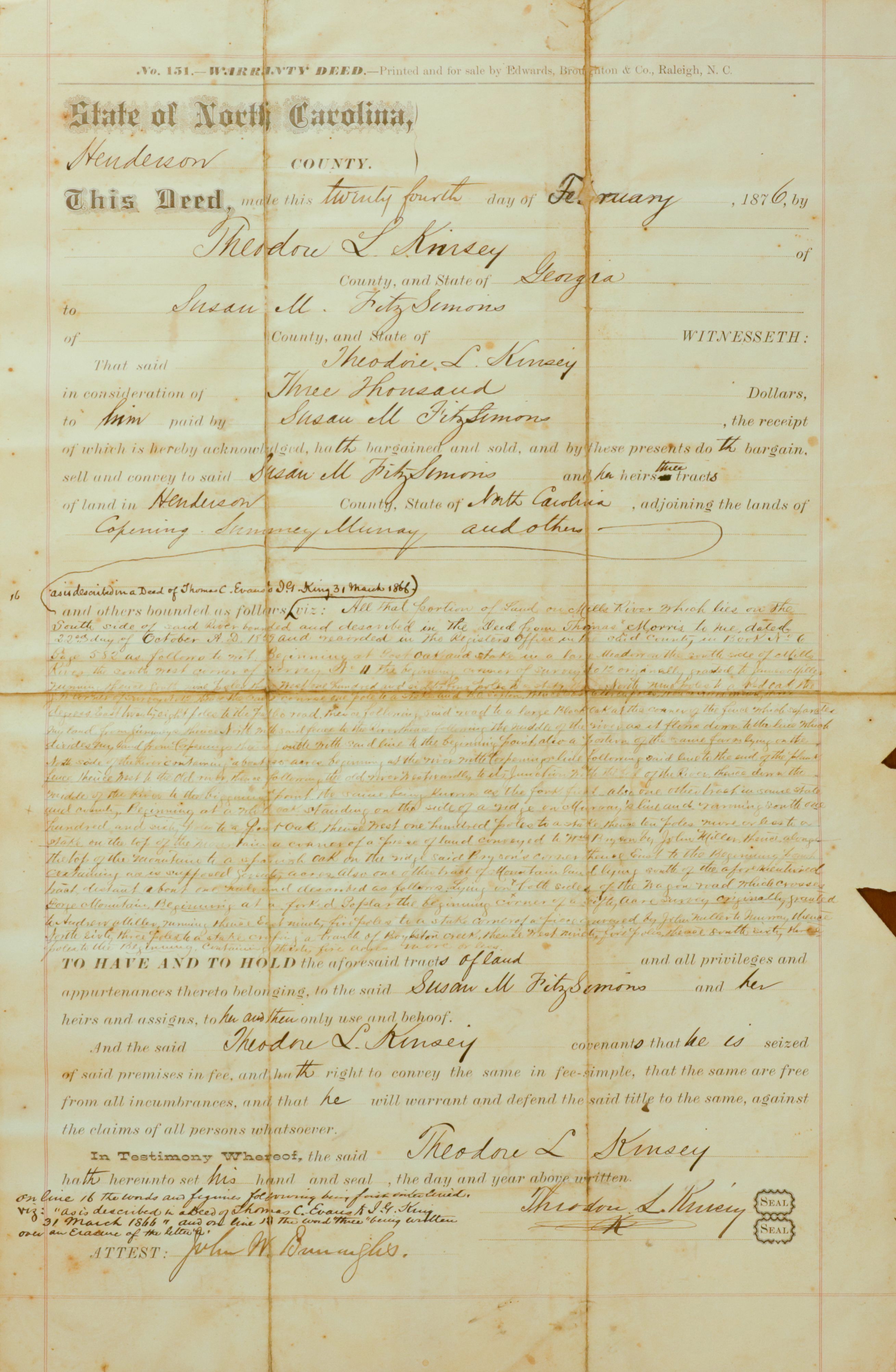
This Deed, made this twenty fourth day of February, 1876, by Theodore L. Kinsey of County, and State of Georgia to Susan M. FitzSimons of County, and State of [blank] WITNESSETH:
That said Theodore L. Kinsey in consideration of Three Thousand Dollars to him paid by Susan M. FitzSimons, the receipt of which is hereby acknowledged, hath bargained and sold, and by these presents do th bargain, sell and convey to said Susan M. FitzSimons and her heirs three tracts of land in Henderson County, State of North Carolina, adjoining the lands of Lepering[?] Twomey[?] Murray and others.
Marginal pencilled annotation (top left of body, beside line 16)
[in pencil, in the compiler’s or a clerk’s hand:] also derived in a Deed of James C. Evans[?] to S. K. King[?] 31 March 1866
Body of description (cursive, three tracts; partially legible)
and others bounded as follows: viz: All that portion of Land [one tract — three] which lies on the South side of said river bounded and described in the Deed from Thomas Morris to me dated 22nd day of October A.D. 1869 and recorded in the Register’s office of said County in Book No. 6, Page 552 as follows, to wit: Beginning at Post oak and Hickory N° 11 the beginning [corner?] of Survey N° 12 originally granted to James Wofford[?], [several illegible words] thence East twenty eight poles to the [public?] road, thence following said road [illegible] thence North [illegible] and from Lepering[?] thence [illegible] [also a portion of the same] [several lines of illegible metes-and-bounds]
[next tract:] [illegible] tract distant about one hundred and described as follows lying [on?] Bone Mountain[?], Beginning at a forked Poplar the beginning [corner of survey?] [illegible] thence East ninety five poles to a stake on a branch of Boggston Creek[?], thence [illegible] containing thirty five acres[?] more or less [illegible].
[third tract:] [illegible] lying on both sides of the wagon road which crosses [illegible] corner of a fifty acre survey originally granted to John Miller[?] [or Mullet?] and Murray, thence [illegible] [containing] [illegible] [acres] [illegible].
Habendum and warranty
TO HAVE AND TO HOLD the aforesaid tracts of land and all privileges and appurtenances thereto belonging, to the said Susan M. FitzSimons and her heirs and assigns, to her and their only use and behoof.
And the said Theodore L. Kinsey covenants that he is seized of said premises in fee, and hath right to convey the same in fee-simple, that the same are free from all incumbrances, and that he will warrant and defend the said title to the same, against the claims of all persons whatsoever.
In Testimony Whereof, the said Theodore L. Kinsey hath hereunto set his hand and seal, the day and year above written.
[signed:] Theodore L. Kinsey (SEAL) (SEAL)
Marginal pencilled annotation (lower left, clerk’s interlineation certificate)
[in pencil:] On line 16 the words and figures following has been interlined, viz: "As described in a Deed of James C. Evans[?] to S. K. King 31 March 1866," and on line 17 the word “three” being written over an Erasure of the letter “s.”
Attestation
ATTEST: [signed:] John W. Dunnaghe[?]
AI Notes
Pre-printed Warranty Deed form (No. 131, Edwards, Broughton & Co., Raleigh, N.C.) with the blanks completed in cursive ink. Dated 24 February 1876. Theodore L. Kinsey of Georgia conveys to Susan M. FitzSimons three tracts of land in Henderson County, North Carolina, in consideration of three thousand dollars. The body cites an underlying 1869 deed from Thomas Morris to the grantor, recorded in Book No. 6, Page 552 of the Henderson County Register’s Office. The descriptive metes-and-bounds clauses for the three tracts occupy the central portion in cramped cursive only partially legible at this scan resolution; firm readings include the Survey N° 12 grantee ‘James Wofford’ and natural-feature starting corners (‘Post oak and Hickory N° 11’, ‘forked Poplar’). Two pencilled marginal annotations are a clerk’s standard pre-execution interlineation/erasure certificate, internal to this instrument, referencing a prior deed of James C. Evans to S. K. King dated 31 March 1866 (not a separate transaction). Signed ‘Theodore L. Kinsey’ with double ‘SEAL’ at right; attested below by John W. Dunnaghe (surname spelling uncertain). The verso (page 289) carries the Georgia commissioner’s acknowledgment.