Newspaper feature: 'Great Names of the Irish' map of Ireland (The Washington Post)
Book 1, Page 122
Transcription
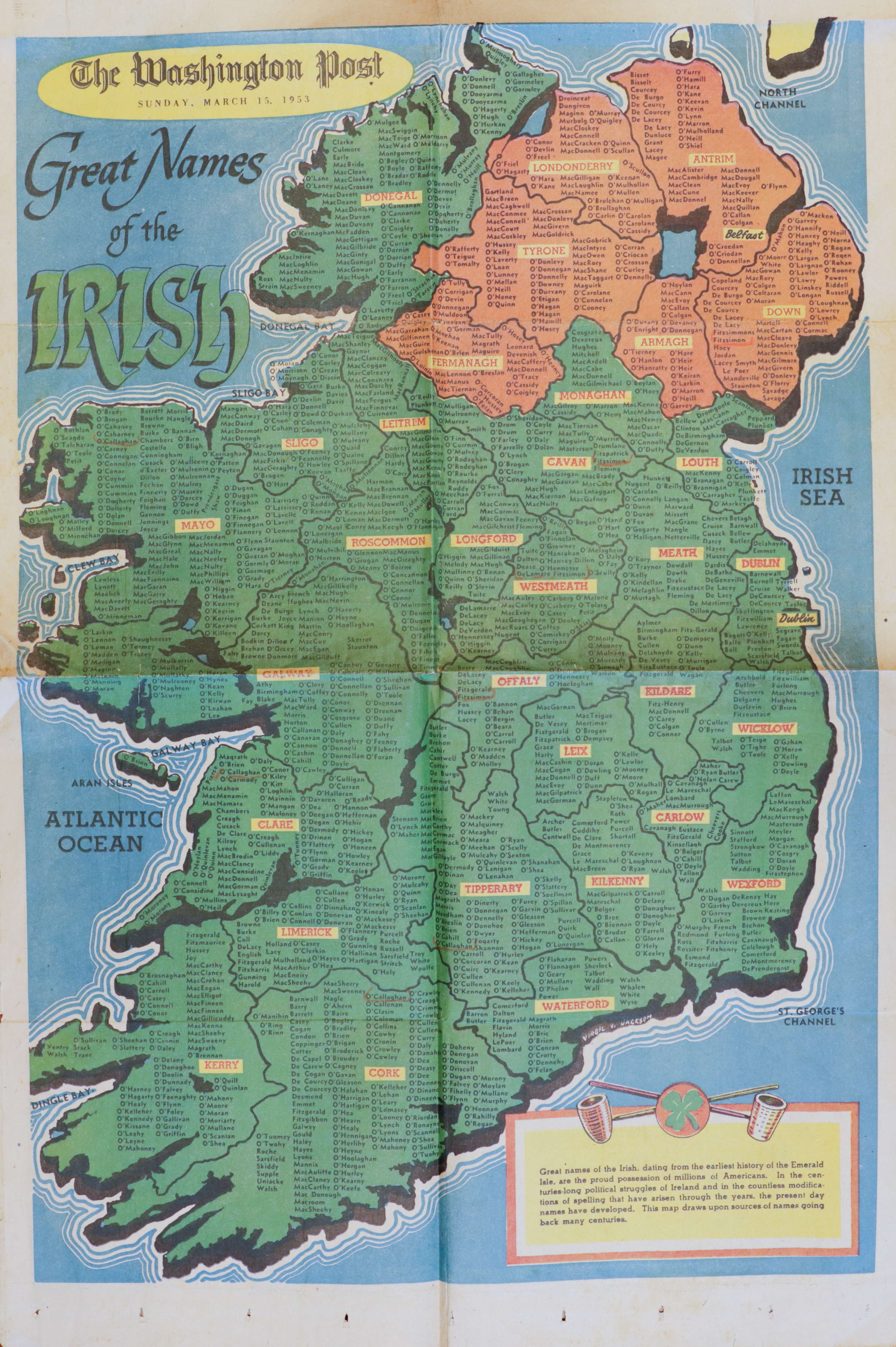
A full-page color illustrated newspaper feature in landscape orientation, mostly filled by a stylized pictorial map of Ireland. Counties are outlined and labelled in orange (north) and green (south). The Atlantic Ocean is to the west, the Irish Sea to the east, North Channel to the north, and St. George’s Channel to the south. Small printed family-name labels appear in clusters across each county.
Masthead and title
The Washington Post
SUNDAY, MARCH 13, [year illegible]
Great Names
of the
IRISH
County labels visible on the map
Among the labelled counties (north and south, as visible):
Donegal · Derry · Antrim · Tyrone · Fermanagh · Armagh · Down · Monaghan · Cavan · Leitrim · Sligo · Mayo · Roscommon · Longford · Westmeath · Meath · Louth · Dublin · Kildare · Wicklow · Wexford · Carlow · Kilkenny · Waterford · Tipperary · Cork · Kerry · Limerick · Clare · Galway · Offaly · Laois
[Hundreds of family-name labels are scattered within each county on the map; not individually transcribed.]
Lower-right caption box
A small inset at the lower right of the map shows two figures and a globe. Below the inset, an explanatory text box (small print, partly illegible at this resolution):
[Small caption text, several lines, largely illegible at this resolution. Discusses the history of Irish family names and how they spread.]
AI Notes
A full color illustrated newspaper feature page from The Washington Post, headed ‘Great Names of the Irish,’ showing a stylized pictorial map of the island of Ireland with hundreds of family-name labels arranged across the counties. The northern counties are shaded orange and the southern counties green. Date line at top reads ‘SUNDAY, MARCH 13, [year illegible].’ A small caption box at the lower right gives a few sentences of explanatory text below a small inset showing two figures and a globe. The map is the front of the folded broadsheet whose inside spread appears on the facing page.
Sunday, March 13, was a date in 1960 — the most plausible year for the broadsheet, published in the days before St. Patrick’s Day (which fell on Thursday in 1960). The compiler kept the Washington Post map alongside the St. Patrick’s Day advertising spread on the facing page (p121, dated to a Tuesday St. Patrick’s Day, most likely 1959) as part of a small cluster of 1959–60 ephemera reflecting her abiding interest in the family’s Cashel-of-Dundalk Irish origins.